Thursday, July 29, 2010

In Russian Alaska


Arrival of these two cruise ships adds more than a third to Sitka's population.

Sitka's radio station began the morning news with the most important news first – just like a real radio station should. “Two cruise ships will arrive in Sitka this morning, Zaandam and Radiance of the Seas. They will bring 3,645 passengers ashore.” People with money were about to arrive. Get your sweatshirts and caps and Alaskan knives and Russian Orthodox gee-gaws out on the sidewalk. The tourists are coming. The tourists are coming.

We drove downtown on a beautiful Chelsea morning. Clouds wreathed the extinct volcano that is the backdrop to the town. But the sparkling sun showered the harbor with diamonds on the water. Delicious.

And in came the tourists. Sitka is too small to permit a cruise ship to dock. So the enormous ships parked out in Sitka Sound and ferried their passengers ashore. The difference between Tuesday and Monday in the little town was the difference between night and day. Sitka has 8,969 souls and was humming with activity. On Monday, we basically owned the town. We could park and walk at will.

We were able to visit St. Michael's Cathedral because the tourists were in. What opulence! Pretty much every wall was tarted up with silver and gold iconography. This is the former Russian capital of Russian America. The cathedral was consecrated in 1748. It was designed by Bishop Ivan Veniaminov who came here in 1834. This fellow truly was a renaissance man. Not only did he create a Russian-Aleut dictionary while working as a priest in the Aleutian Islands, he started another dictionary for the Tlingit aboriginals when he arrived here. He was a carpenter (constructed his own throne, plus lots of furniture in the Bishop's House which we visited on Monday). He also was a self-taught mathematician. Ninety percent of the congregation in the cathedral today is Tlingit.

The bishop was canonized as Saint Innocent in 1977.

On Monday, we'd visited the Bishop's house, a large but plain structure. It is the best preserved of four Russian structures in the western hemisphere. We then walked through the Sitka's National Historic Park where there is a collection of totem poles. Each tells a story about a Tlingit clan which was explained to us by using our cell phone. There is even a totem with a white man at the top. This totem story tells a story of thievery of shell fish and other goods. It was carved so the wrong could be righted. Was it? Doubtful.

Many of the stories of the poles dealt with the raven, which is considered the trickster who plays with men's lives. There are carving of whales, orcas, bears, frogs, as well as the topmost part which often shows a man in what looks like a top hat. They are actually the watchmen of the clans. The top hat get taller and taller as the watchman gains in stature.

We boarded Columbia for the next leg of our voyage south. Because this was an overnight leg, we got a berth so we could sleep in comfort. Some of our fellow passengers were much more rugged. They set up their tents on the rear deck, holding them down with duct tape.

We awoke in the middle of the night when we docked in Petersburg. Then we were off, through Wrangell Straits, arriving at 7:45 a.m. On time.

Jo was the first vehicle off, aboard the Honda Fit. I was not to lucky. I was the largest rig aboard and the crew had me back up about 50 yards with one inch to spare on each side of the rig. Just a little stressful!

We parked in a Tlingit-run campground to the south of the little town. Wrangell is too small to receive and handle cruise ships and, as a result, calls itself “the true Alaska.” Well, maybe. There were little kids on the waterfront, selling garnets they are allowed to chisel from the rock face across from the town.

The town has about 1,800 people– down from 2,550 in five years. “The young people leave here and never return,” one local woman told us when we visited the petroglyph beach. This is a place where 8,000-year-old petroglyphs (carvings in stone) are lying on the beach between high and low tide marks. They are thought to have been created by the people who came to Alaska before the Tlingit Indians.

Just north of the petroglyph beach is Dead Man's Island. Back in the 1800s, Chinese workers at the local salmon canning factory were taken there when they died. Their bodies were pickled in brine and placed in wooden casks before being shipped back for burial at home in China. All of this is described in great detail by James Michener in his must-read novel, “Alaska.”

In the evening, we drove and hiked to Nemo Point, south of town. We had the place to ourselves and the perfection of the peaceful scene left us breathless. We sat 2,000 feet above Zimovia Straits and watched the fishing boats shuttle back and forth in the sparkling waters below. There was not a sound to be heard at this height – not even a bird. Jo maintained a soft chatter – mostly to alert bears of our presence - but none appeared.

We managed to get into Chief Shake's House on the waterfront on Thursday morning. This is a Tlingit tribal house. The carvings inside were extraordinarily good (see photo album). Happily, Chief John, a Tlingit who also is of the Wolf clan, spoke with us about the traditions. He also showed us a traditional Tlingit canoe he himself had carved 15 years ago. Beautiful workmanship and lines to this little vessel.

Sunday, July 25, 2010

Death in the Afternoon


This female sockeye salmon finds the perfect spot in her natale stream to place her eggs.

The end is near for the hundreds, no, thousands of sockeye salmon in the creek that runs into Gastinaeu Sound, Juneau.
There is something exquisitely sad in the watching of this death and life drama play out. The salmon congregate in the stream, flicking their tails as they burrow to create a safe place to drop their millions of eggs. They are spent. They are surely at the end of their cycle for the dorsal fins are ragged, there are cuts and breaks on their mouths. But there is this sense of divine destiny in the air. They have this final mission: return to the stream of your birth – your natal stream – and lay the eggs that will allow the cycle to continue.
They left this precise stream two to five years ago. They found the great Pacific and wandered through the ocean. This came after they had been born in the stream and absorbed their yolk sacs. After emerging from the gravel they fed on tiny aquatic insects. Chinook, coho, and sockeye salmon spend one to three years in fresh water before migrating to the ocean. Pink and chum salmon migrate directly to the ocean after emerging from the gravel. The young salmon are called “smolts”.
Now the sockeye had made their return. Think about the shock to their system as they make the transition from life in the salt water to life in the clear, fresh stream that roars down from the mountains that make the dramatic backdrop to Juneau. They have long since stopped eating. Now they have one task and one task only: spawn.
The eagles and the gulls stand on the banks of the stream and wait and wait and wait. They surely know from where their next meal is coming.
When the salmon has spawned and the eggs have rested in the comparative safety of the stream bed, the male sockeye moves in and fertilizes. Then they die. It is that sad and that simple. They have completed the life cycle. They gasp on the bed of the stream, they lie on the bottom, letting the fresh water pour over them. And they die. Hundreds of thousands of them just die.
It is moving and sobering to watch this scene play out. There is no joy here. But there is a sense of “mission accomplished.”

The night before we left Haines aboard the Matinuska, the oldest ship in the Alaskan ferry system, we were alerted to something on the beach in front of our RV by a tap on our door. A Grizzly Bear was wandering on the beach. He was young, looked to be about 500 pounds in weight and walked and ran at a frightening speed. He'd stand on his hind legs, rising to an intimidating height of six or seven feet. Then he'd run again. Even though the sun was set, I grabbed my camera and tried to photograph this bear. The result is interesting, to me. Because of the long exposure I was lucky enough the create an impression of the bear.
The following morning, we drove to the ferry and there he was again, crossing the road in front of us. He stopped, gave us a look, then trundled on down the bank at the side of the road. This is one of the things that makes this the trip of our lifetimes.

Thursday, July 22, 2010

It's about FREEDOM


Dave Stancliff and his teenage musicians entertain us with stories about Alaska at the Tok RV Resort.

Dave Stancliff was our entertainer of the evening. He is a guitar-playing-songwriter and story-teller about all things Alaskan. We were in Tok RV Park and his concert was part of the services offered. Tok is 90 miles from the Canadian Border and is a key crossroads since this is where you have to decide whether to head for Anchorage or up to Fairbanks. He was accompanied by three high schoolers - Jenny on the fiddle, and brother-sister team Huff and Holly.
Jenny told us the schools never close because of weather in Tok. But, when the temperature drops below minus 30F, the kids are allowed to skip school without it counting against them. But she said she'd gone to school earlier this year when the temperature was minus 73F. This may explain why she was school valedictorian at graduation this year.
They entertained well enough but Dave's stories were what enthralled. He explained why he has spent the better part of his 60 years in Tok. “No taxes, no law enforcement, no laws so you can't break any. We're free.”
Jo fretted about this after the concert. She couldn't figure out how anyone could live without paying taxes. But it was clear there were no services in Tok. But she persisted. “Who is paying the teachers, building the schools and fixing the roads?” So we decided to stop by the office on our way out on Tuesday morning. The woman behind the counter was quite happy to answer Jo's questions. “We decided not to vote ourselves into a borough,” she said. “So we have no town officials, no building inspector, no police, nobody who wants to 'help' us.”
In answer to the next question about schools, she said the state pays. “But who pays the state?” I asked. She looked at me as if I were an idiot. “The oil pays, of course,” she said. Same goes for the repair of the highways. Because Tok is unincorporated, the state has to maintain the roads. What about the state police? Same answer. State pays.
So if you, by now, are getting aboard your SUV and heading north to live free, I'd recommend against that. While the country is spectacular and the wildlife is unmatched, we're not over-enthused about the run of the mill Alaskans we have met. Obviously there are exceptions, but we have found them to be self-centered and very much looking to pick a fight with anyone who believes the federal government can actually do anything worthwhile. The Alaskans we've met – many of them – remind me of branch office workers I've worked with over the years. When you're cut off from the mother ship an inevitable sense of second-class citizenship seems to built and you are quick to look for slights and the sense that the main office doesn't really care much what happens to you. Everything bad happens in the lower 48 states, from many of their points of view. Finally, they drive with such foolishness, ignoring double yellow lines on the two-lane roads, that it is a miracle there are not more deaths from rollovers. And there's hardly a road sign that hasn't been shot out with bullets.
But life is pretty free. It really does live up to its license plate logo: “The Last Frontier.”

On our way to the border on Tuesday, I was fiddling with our computer navigation program when Jo, who was driving, slammed on the brakes and said, Oh my God! Oh my God. Oh my God.” By the time I looked up, a female moose and her calf were ambling onto the highway 15 yards ahead of us. Jo swerved and brought the rig to a halt. I grabbed my camera. But mom and her calf decided they had enough of this and quickly scooted back down the hill and into the trees.

We decided to revisit Kluane Lake, one of our favorite spots in the Yukon Territory. Amazingly, our first campsite was vacant and we moved in. A Swiss couple and their grown son arrived by van and set up their tent beside us. There are warnings about doing this between mid-July and September because this is bear country and the soapberries are out right now - a favorite of the grizzlies. They had flown into Yukon (Whitehorse, actually) from Zurich and rented the van.

The campground view was just as - if not more - spectacular. much of the snow is off the high peaks. But the wreathing clouds on the mountains made the place mysterious and cozy.

We arrived at Haines on Thursday afternoon. Haines is our departure point on the ferry system. Our car and rig are coated in dirt from the gravel road we traveled for 100 miles from the U.S. Border into Canada. I call this the 100-miles-of-hell highway. It is bone-jarring and hard on the vehicle. The only solution is to drive at 25 miles an hour. And that doesn't keep the dirt down. But it doesn't ruin the rig.
We parked on the waterfront in Haines and licked our wounds. The car didn't start when we unhooked it from the rig: our first real casualty. We jump-started it and then ran it for a few hours to charge the battery.
We head out aboard the ferry on Saturday morning and will make stops at Juneau, Sitka, Wrangell, Ketchikan and leave the ferry when we reach Prince Rupert, British Columbia, on Aug. 1.

Monday, July 19, 2010

Free Fish


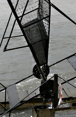
The fish wheel spins in the river and scoops up salmon that are trying to head upstream. The buckets dump the fish (lower, center) into a box alongside the wheel.

The fish wheel is a perpetual motion machine. The Copper River propels it. We received permission from Angus DeWitt, the grumpy Athabaskan native on whose property the wheel is located, to drive through and look at the wheel. As we stood on the bank on a drizzly evening, the river roared through on its way to Valdez. The salmon, heading upriver to spawn and die, have to run this gauntlet. There's an immature – but enormous – eagle perched on a fallen tree halfway across the river. He's waiting to see what he can collect.
The roaring river hits the baskets in the wheel and propels them, scooping up anything that is trying to pass upriver.
I made my way down the slippery bank and looked into the box at the side of the wheel. There were six salmon lying in there. I retreated to the bank and waited two minutes. A salmon appeared in the rotating wheel. It ferociously tried to find its way out of the scoop. He fell, twisting on the way down, and fell onto the wheel support system. It took him a second to wriggle off the wood and back into the river. Whooo! Close call. Two minutes later, the same thing happened. Two minutes after that, however, a salmon ended up in the scoop and didn't move fast enough. He ended up being caught in the box. Another few minutes passed and yet another salmon was picked up but escape death by performing a wonderful leap that took him to freedom.
The wheel is owns by someone other than Angus (which probably accounts for his grumpiness). You are welcome to pick out a fish (you are permitted 250 salmon per year). But you must report to a Ranger station to show a fin, along with the permission you have received from the wheel owner to collect fish. The Ranger will contact the owner to verify you have his permission.
We came here to Slana, in the middle of the wilderness on the road between Glenallen and Tok, on a visit to Brian and Jean Johnson's little cabin. Seven years ago, Brian had bought the shell of a cabin and five acres of land from a homesteader. The cabin housed the local preacher and was one room. He set about living in the plywood box while he strengthened the structure. He added insulation and then added log facing to the cabin. He built an attic bedroom and installed a couple of support beams to carry the load.
Brian said when he showed Jean the original cabin/hut she stood there and just laughed. But they have carved a beautiful little home in the wilderness. Life took a step toward modernity two years ago when the electric grid came through. Till that time, they had been living with a loud and heavy generator. “It was tough to get that started in the morning when the temperature was 30 degrees below zero,” Brian said. They would drag the generator into the cabin and warm it in front of the wood stove. Then they could get it to start. They found if they bought a smaller generator, they could start that after storing it inside the cabin. The heat from the exhaust would then be pointed at the larger generator and that would eventually unfreeze it. So the arrival of the electricity was an enormous boost for them.
The couple said moose wander into their front garden regularly. The female moose have a nasty tendency to snap off the birch trees. They do not bother to munch on the lettuce and potatoes the couple grown.
Brian explained how he and his wife benefit each year from the Alaskan Pipeline fund. He said they each receive around $1,250 per year. This changes, depending on the flow of oil and has been as high as $2,500 per person. You must own property in Alaska and stay in the state for a minimum of six months and a day to reap this benefit.
We parked on a gravel pull-off space at the front of the house and were sitting in the living room when Steve, a neighbor, stopped by. He offered the couple some salmon that left over after he'd married off one of his daughters the previous day. We received a whole, cooked salmon which we chopped up and stored in our freezer. Steve is a trapper and artist. He told me he runs two trap lines, usually between late October and April. “I'll run one trap line one day, the other the next day,” he said. He traps martens, fox, wolf, mink. He says he find the meat of these animals is not that tasty, although he is partial to beaver. “Tastes like high quality beef,” he said. His wife makes hats from the pelts and they make jewelry from the teeth.
The previous day, Saturday, we'd driven to Wrangel-St. Elias National Park. This is a huge wilderness – 12 million acres and the park abuts the Kluane National Park in Canada. The place is pristine with huge mountain ranges and endless glaciers. But it is not very accessible – only two roads lead into the park. One of them is prone to being closed by washouts. This happened to be the case when we headed down the Nabesna Road. It had washed out and was closed.
We hiked through the boreal forest with a park ranger and learned much about this largest organism in the world. It extends across all of Canada,, from Newfoundland-Labrador, crosses into Russia and China and ends in Scandinavia. Many of the trees are white and black spruce. In addition, quaking aspen is a major player in the forest. We learned about the “drunken forest” caused by the tilting of shallow-rooted evergreens because of the permafrost. We came to appreciate the fragility of the permafrost. If you melt it, it can never be restored to the original state. Parking lots, and highways do a great job of destroying the permafrost – hence the roller-coaster ride in mainland Alaska where the permafrost heaves and sags because of the highway heat.

Monday, July 19, 2010
We drove north to Tok, a small crossroads town 90 miles from the Canadian border. We checked at the visitor center and discovered the road farther north, to Chicken, was opened this morning. But we've decided not to push our luck by driving this ragged road after the washouts we'd read about earlier in the week. We'll head for the Canadian border and retrace our route to our favorite campground of the entire trip at Kluane Lake. Then we'll head down to Haines, Alaska.

Friday, July 16, 2010

Land of Giants


These are just a couple of the giants...from the Alaska State Fair.

We're in the Matanuska Valley, northeast of Anchorage. This is the vegetable garden for all of Alaska. But not just ordinary veggies, of course – whoppers. Here's a list of some of the records set for vegetables grown here:

35 lb. Broccoli
28 lb. Brussel Sprouts
127 lb. Cabbage
19 lb. Carrot
18 lb. Leaf Lettuce
83 lb. Rutabaga
569 lb. Winter Squash
168 lb. Watermelon
22.75 inches for the longest bean
16.75 feet for the tallest Sunflower

And it goes on and on. The reasons for this richness in the soil: glaciers. They macerated the rocks and created deep topsoil.

But the real story about this valley occurred in 1935 when President Roosevelt's administration colonized the valley by shipping 202 families from Michigan, Wisconsin and Minnesota here. They generally were farmers on the dole during the Depression. They were suffering through the worst drought in U.S. history. And they had nothing to lose when the government asked for volunteers to colonize this valley.

They came west by train, then north by ship. They initially were housed in tent villages built by the Civilian Conservation Corps. They were allowed to draw lots to receive their 40 acres of land. The deal included a house with between one and three bedrooms (depending on the number of children they brought with them), piped in water, a chemical toilet, and a repayment schedule that seems like a bargain to us: 30 years to pay back the government $3,000.

Amazingly, only 40 per cent of the families stayed on. Many buckled under the wilderness conditions, and the lack of medical support when their children began to die of measles and pneumonia. Eleanor Roosevelt eventually pushed hard for a hospital to be built for the colony. It's an interesting story of pursuing the American dream. There now are three of the original colonizers who continue to live today.

While I'm writing about records, you might as well indulge in some others about Alaska:
Alaska's coastline total 33,904 miles.
The U.S. Bought Alaska from Russia for 2 cents an acre... total cost: $7.2 million.
Alaska contains the northernmost (Point Barrow), westernmost (Amatignak Island) and easternmost (Semisopochnol Island, across the International Dateline) points in the U.S.
And Alaska's capital, Juneau, is the only capital in the U.S. With no road access; a boat or plane is the only way to get there.

Thursday, July 15, 2010

A Map at Last


In response to requests from our travelers, here's a map that shows our route through Alaska. We headed north to Fairbanks, came down to Anchorage, spent much time in the Kenai Peninsula. We sailed out of Seward and are now heading north and east. We arte in Eagle River, northeast of Anchorage.

If you click on the map, you'll enlarge it. If that doesn't work, Right click and choose "Open in a new tab". That should allow you to enlarge.

You might be interested to know we have had to have a major change in route on our way to Haines, Alaska. We'd planned to drive to Tok, then up to Chiucken and across the Top of the World Highway to Dawson City and down to Whitehorse, Yukon. But the road beyond Chicken was washed out in numerous areas after the river rose 20 feet on Saturday. There are a number of RVs trapped up there right now. So we will go to Tok, then head down to Haines Junction and on to Haines, where we are booked on the ferry system. It will cut 550 miles from our adventure.

Tuesday, July 13, 2010

Laughter in the soul


This Humpback calf came alongside to entertain and explore before we came up close and personal with the Northwestern Glacier.

We were floating in the very center of Northwestern Fjord, in the Gulf of Alaska. The captain of our vessel, Alaska Explorer, had taken the engines out of gear. Now he put one forward and one in reverse and the vessel spun on her own axis. As he did this, I held my camera and recorded the majesty of the scenic panorama as it passed in front of my lens. I was laughing inside...laughing in the soul, you might say, for this was a wondrous moment. He allowed me – and the 121 other passengers to experience that sublime moment that comes but once or twice in a lifetime. This was that time.

The mountains surrounded us. The sky was cerulean blue, not a cloud was to be seen. As the boat pivoted, one glacier after another appeared in my viewfinder. The peaks were coated in snow and ice. Behind the peaks lay the Harding Icefield, all 334,485 acres of it, concealing mountains that lie under several thousand feet of ice. The glaciers, even though they are retreating at an alarming rate, are sky blue. And they are always on the move.

The captain, when we had pulled up alongside Northwestern Glacier, stopped all engines and said simply, “This is the time when I let the glacier speak to you.” And she did. She groaned, she rumbled, she belched and she let go of her ice which came crashing down, calving into the fjord. The kittiwakes, floating on the bergy bits teetered and floated along unperturbed. The harbor seals, great sausages of sleek fur, lay basking on the floating ice, the sun warming them, they in all their glory on this perfect day.

Before we had reached the fjord, we'd come down the Gulf of Alaska and had come upon a mother humpback whale and her year-old calf, “a 2010 model” our captain called the calf. The calf was exceedingly curious. He leaped from the water and then made his way over to our stopped boat. Mama lay back, allowing him to explore. He gave us such a show, rolling, breaching, popping straight out of the water, newly-grown barnacles on his jaw.

We poked into one cove after another, each a treasure trove of wildlife and birds. /a mother otter lay on her back with her baby on her belly. Sea Lions basked high on a rock, the bull surrounded by his harem. He bellowed his displeasure as we stood off at about 50 yards while the sea lions basked in the building tide. Black oyster catchers, with enormous red beaks nested among the pebbles on one beach. Horned puffins, as well as tufted puffins fluttered like bats. They both are members of the Alcid family. This species come to land only to nest. Then they produce their young and head out for three years . They propel themselves through the water with their wings which are quite different from other species of birds. Their wing bones are solid to provide more strength for “underwater flying.” When they fly they always flap their wings. The moment they stop flapping, they begin to fall.

Jo and I befriended an Indian couple aboard our vessel, he from Mumbai, she from New York City. They had two delightful daughters and had flown to Anchorage and then rented a small motor home. He worked at Microsoft in Seattle and she was an independent entrepreneur who had started her own wholesale and retail business on the Internet. He was determined to catch salmon and/or halibut and to fly to Kodiak Island to see the Grizzly Bears catching their salmon.

The weather deteriorated as the afternoon wore on. We were back in the Gulf of Alaska and the waves rose along with the swells. The captain did a fine job of minimizing the impact by working toward the windward shore so we were less subject to the unpleasant effects of the sea. But it also was good to return to the harbor, tired but uplifted by the extraordinary experience with nature at its best.

Sunday, July 11, 2010

Close Encounters with Eagles...and Finding Glaciers


Jo stays warm in her arctic parka while viewing Exit Glacier in Seward.

Next to messing about in boats, there may be nothing quite so enjoyable as lingering by the banks of a river, watching fishermen casting for their fish. And it matters not whether the fish are there or choose not to take the bait. We sat by the side of the Russian River, on the Kenai Peninsula, watching this scene and transported by the dreams of all the fishers who lined the banks and who took to dories. This is the time the salmon will make their run upriver. The salmon are downriver in Soldotna, a fisherman told me. But they haven't found their way up the icy turquoise-colored glacier river yet.
We'd planned to stay the night alongside the river. There's a primitive cable ferry here that will haul you and your gear to the other side of the racing river – it flows at around 6-7 knots and the ferry is hauled back and forth on its cable while the skipper strains at the wheel to keep the boxy vessel pointed into the roaring stream.

We had come up from Anchor Point, the most westerly point in them North American continent that is serviced by a highway. The point is at longitude 151.83746 degrees west of Greenwich, England. We had come to that place not to check off the “most westerly point” but to spend time up close with Bald Eagles. We were not disappointed.

Jo and I first wandered through the underbrush, alongside the Anchor River. We rounded a bend and there was the river. More importantly, there were the eagles. They had caught their own salmon and they took turns tearing at it and gulping down the rich meat and roe. They were surrounding by a haranguing retinue of gulls and crows, all of them hollering and yakking trying to claim their piece of the action. The eagles were silent since they owned the salmon. And they had no intention of sharing their catch. I walked the bank and they watched me. I tried to get close so I could capture the moment. The eagles worked with me and I was able to capture the feeding frenzy.

After supper, we wandered to the beach and found a whole new batch of eagles cleaning up the halibut guts that fishermen had left on the shore.

I worked my way along the stony beach, closing with a particularly handsome bird. He just stood on the sand offering himself to me. It reminded me of years ago in Africa when a klipspringer, a small antelope, stood in the cleft of a red rock face. He waited for me to work my way up the rocks so I could photograph him in the cleft. When I showed that picture to one of the reporters later and told him how the klipspringer had awaited me, Christoff Maletsky looked at me and said simply, “He offered himself up to you, Robert.” Christoff, of the Damara tribe, had grown up in the area where I'd been photographing and he knew the animal life intimately. So I experienced the same sense while working with the eagle.

He permitted me to gently approach him. I had started out 50 yards away. I edged slowly up the beach, trying not to disturb him. He looked at me with those awesome eagle eyes. He projected the sense that he could see me from 50 miles away. When I stopped about 10 feet away, I sensed he was getting a little nervous. Perhaps I was pushing into his personal space. Ten feet, though, is close enough. When you are that close, you can see the enormous talons. You can see the hooked beak. You can sense the massive power of the bird. I never felt in danger. But I did sense he could do with me what he wished with those talons and beak.

He allowed me to photograph him so his entire head filled my viewfinder. And then he turned his back and waddled along the beach for about 10 feet before opening his wonderful wings and lifting off with the greatest of ease. Now that was a moment as close to perfection as I have ever experienced.

Sunday, July 11
We've moved again, this time to Seward. What a drive this was. You come south between jagged peaks that are part of the Harding Icefield. There are too many glaciers to count – and all of them receding at record rates.
We parked on the edge of Resurrection Bay, in the city of Seward, and immediately set out for Exit Glacier. This is one of the few that are reachable on foot. We hiked into the Kenai Fjords National Park, passing many Japanese tourists who seem to take great delight in always photographing themselves at every outlook area. There must be something in the national character that demands to record their presence. We watched a father endlessly shoot his wife and two precocious children. When I offered to take his camera and photograph him with the whole family, however, he said, “No thank you.” Whatever.

Because we do not expect to come this way again, we have booked passage on a boat tomorrow for a 9.5-hour journey to Northwestern Fjord.

Tuesday, July 6, 2010

On Wings of Eagles


This is a composite picture of the many Bald Eagles flying over the Ninilchik River area.

Hello. Ting Lee here. Just wanted to give you the lowdown on what I've been doing during the past seven months.
Today will be one of the more memorable of my life. We are, I'm told, on the banks of the Ninilchik River on the Kenai Peninsula. I got my first exposure to the giant bird you know as the Bald Eagle. Not just one.... but seven of them flew over, swooping and looking very menacingly at me. Now, I'm no fancier of bird flesh – I mean, I always get excited when I see birds chattering away – but these birds are 'way out of my league. They are huge. They have enormous talons. They do have a funny cheep that they make and it seems too small for their size. They were drafting on the uplifts from the cliffs at the mouth of the Ninilchik River. I'll never forget these birds.

Robert and Jo went into a church in Ninilchik that had been built by the Russians back in the 1800s when their fur traders sailed this coast. They met up with a man dressed in black, with ringlets hanging from his head. I didn't get into the church – unseemly for a cat to be in a church, the parental units said. But the man explained why the Russian Orthodox cross has two crosspieces on it, the lower one tilting up to the left. “This is pointing to the good thief on the cross beside the Lord Jesus Christ,” he said.
Robert asked about the congregation and the man explained there are only 20 people now who worship in the church. The services are mostly in English, although the older members like the Slavic tongue to be used, the priest said. “But all who lived here in the past come and are buried here when they die,” he said.

Robert said he noticed there were three new graves, in the cemetery. The cemetery is completely overgrown with weeds, so the 20 members of the congregation seem to have lost their need to maintain.

The man explained that the church leadership now resides in Long Island, New York. There are no ties to Russia since the Communist Revolution of 1917.

The parentals left me in the evening and returned to the mouth of the Ninilchik River. There, they spent the evening photographing more Bald Eagles. They said the eagles land on their prey like lions. All the gulls makes way for the eagles but are not happy to do so. They skulk around in circles and cry out their annoyance – very similar to hyenas at the water holes of Namibia, Robert says.

Two juvenile eagles and their papa landed together on a spit of land off the river mouth. They worked at tearing the discarded entrails of a halibut between them. Then, they split up and the mature adult flew off down the stony beach where he landed and offered himself up for a great portrait.

In the meantime, the fishermen, in their sturdy aluminum craft, headed back toward the mouth of the river. There were more than 65 boats crowding the mouth of the river, waiting for enough water to permit them to enter. A couple of boats edged in but immediately ran aground. One smaller boat came through, creating a giant wake and he rocked the stuck boat off the bar. But mostly the others had more patience and just waited for the tide to rise enough to permit entry around 10:30 at night.
There they unloaded their catch – halibut and salmon – into plastic containers. These were weighed then iced at the dock and loaded into a truck for transportation. The young girl who shoveled the ice and moved the boxes seemed to have the hardest job in the world. Her dad ran the forklift.

Tuesday, July 6, 2010
This morning we arrived in Homer, Alaska. This is on the most southerly spit of land on the Kenai Peninsula and is the halfway point, more or less, of our journey. Now we will head north and east after a few days.
We now have traveled 7,055 miles.

Thursday, July 1, 2010

Slip Sliding Away


This bergy bit is a breakaway piece of the Portage Glacier on Portage Lake, Kenai Peninsula.

This is your final warning: Get to the Kenai Peninsula as quickly as possible. Please don't wait another year. It might be too late.
We are on the northern edge of the peninsula – just a hop-skip-and-jump for Anchorage, 50 miles to the north.
We drove alongside Turnagain Arm, perhaps one of the prettiest drives in all of Alaska. It was named in 1778 by William Bligh of HMS Bounty fame. Bligh served as Capt. James Cook's Sailing Master on his 3rd and final voyage, with the aim to discover the Northwest Passage.
Upon reaching the head of Cook Inlet, Bligh was of the opinion that both Knik Arm and Turnagain Arm were the mouths of rivers and not the opening to the Northwest Passage. Under Cook's orders Bligh organized a party to travel up Knik Arm, which quickly returned to report Knik Arm indeed led only to a river.
Afterwards a second party was dispatched up Turnagain Arm and it too returned to report only a river lay ahead. As a result of this frustration the second body of water was given the disingenuous name "Turn Again".
The place is just crawling with glaciers. But the end is in sight. The glaciers here are in full retreat and what we saw will not last much longer. But what we saw is simply incredible.
We arrived on a dank, dismal day with low clouds shrouding the snow-covered mountains. We camped in the Chugach National Forest amid alders with their fluttering leaves. The mountains rise up in front of our RV through the mists.
We made our way by car to the nearby visitor's center and became immersed in the world around us. When we watched the movie of the Portage Glacier, we were inspired – but, at the movie's conclusion, the screen rose up, the curtain parted and we all sat before a glass wall that looked across Portage Lake. The glacier which had been visible when the center was built just a few years back, and which was designed to be the star of this presentation, has retreated around the side of a mountain and is out of sight.
We were a little depressed at this. But after a good night's sleep we decided to investigate. We hiked two miles up a path, gratefully wearing our anti-mosquito equipment. We arrived at Byron Glacier which, while retreating, also is a spectacular sight. The blue ice is a thick carpet for the underwater stream that pours down the mountain under the ice. We trekked onto the snowfield and photographed the beauty of it all.
Then we headed by our car through a tunnel that had been built in 1942 to permit supplies shipped into the port of Whittier to get inland. This tunnel, which run 3.5 miles through a mountain, now has been modernized so cars, RVs and trucks, as well as trains share the passageway. Trains go first. Then east-bound vehicles, then trains heading west, followed by vehicles. It's a toll road that is actually paying for itself. We arrived in the little town of Whittier which isn't much to write home about. There is an impressive harbor with lots of heavily built sailboats and powerboats. Many fishermen come through the tunnel, dragging their boats behind them. And the fishing is just beginning as the salmon is beginning to make their run back upstream to spawn. They are running two weeks late this year for some reason. So we are just at the start of this wondrous journey.
As we returned through this tunnel, the sun welcomed us on the Portage side. Not a cloud in the sky, spectacular visibility. We again visited the visitor center and listened to the recordings of the aboriginal people, telling about the subsistence lifestyle. We also heard recorded stories of a gold miner who was attacked by a Grizzly Bear. He was badly mauled but managed to roll away while the bear collected her cub. But then the bear made one more attack on the old man before leaving him. He then had to walk 20 miles through the mountains to Seward to get medical help. They don't make 'em tougher than that.
We listened to a geologist who had been walking and taking measurements on Portage lake when the massive 9.2 earthquakes his Anchorage in 1964. The quake continued for more than four minutes – a lifetime in quake history, since they normally last around 30 seconds. He said the frozen lake began to buck under his feet. Water disappeared under the ice, then returned and pushed through the frozen lake. He and his men scrambled for their lives and were rescued later in the day. In Anchorage that day, the quake was so violent that a subdivision on the south side of the city fell 30 feet and hundreds of homes disappeared. We had walked the path to this subsidence. There is a cliff there now and low wetlands where homes used to sit.